THE MOSER ACTIVE DIENTES DE NAVARINO TREKKING GUIDE
is designed to help you organize and plan your trekking trip. You will find a lot of useful information about trekking in the Dientes de Navarino Mountains on Tierra del Fuego such as climate, how to get there, equipment, trekking guides and porter service. We have compiled the questions from customers and hikers from all over the world, which have been addressed to us as a local trekking tour operator for over two decades, and answered them in detail here.
Tierra del Fuego
Tierra del Fuego is the southernmost tip of South America. In addition to the large Tierra del Fuego island, it includes several small islands, including Isla Navarino. The archipelago is separated from the mainland by the Strait of Magellan. The islands were discovered by Ferdinand Magellan in 1520. At that time they were already inhabited, as indicated by the many fires that gave them their name. Just as in the past, this mysterious and fabulously beautiful region still exerts a magical attraction on all true adventurers.
Dientes de Navarino - Tierra del Fuego
[Translate to English US:]Dientes de Navarino - Tierra del Fuego
Dientes de Navarino - Tierra del Fuego
[Translate to English US:]Dientes de Navarino - Tierra del Fuego
Dientes de Navarino - Tierra del Fuego
[Translate to English US:]Dientes de Navarino - Tierra del Fuego
Dientes de Navarino - Tierra del Fuego
[Translate to English US:]Dientes de Navarino - Tierra del Fuego
Dientes de Navarino - Tierra del Fuego
[Translate to English US:]Dientes de Navarino - Tierra del Fuego
FREQUENTLY ASKED QUESTIONS – DO YOU PLAN A TRIP TO ISLA NAVARINO ?
Which is the Best Hike on Navarino Island?
The island of "Isla Navarino" in the Tierra del Fuego archipelago in southern Chile is home to some of the most spectacular landscapes in South America and offers one of the most challenging and beautiful hikes in Chilean Patagonia:
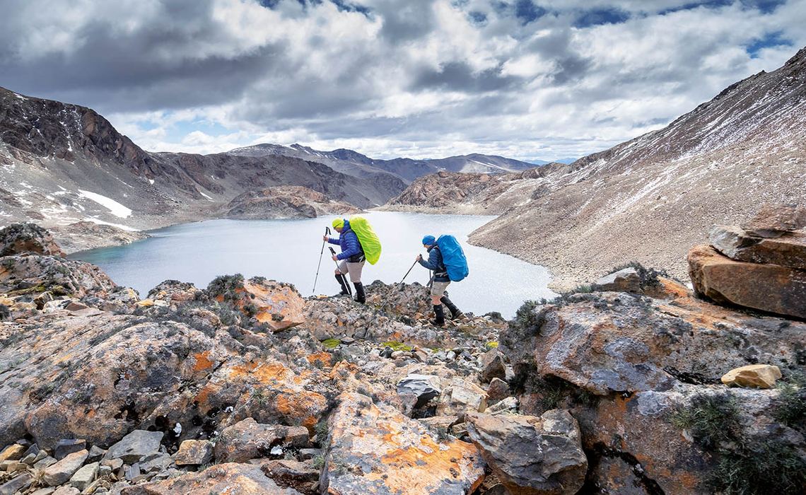
The Dientes de Navarino Circuit - the southernmost trek in the world - is a wilderness trek for experienced hikers and adventure seekers. The multi-day hike leads through beech forests, snowfields and glacier lagoons around the rugged Dientes de Navarino mountains.
HOW MANY DAYS DO I NEED FOR THE DIENTES DE NAVARINO CIRCUIT?
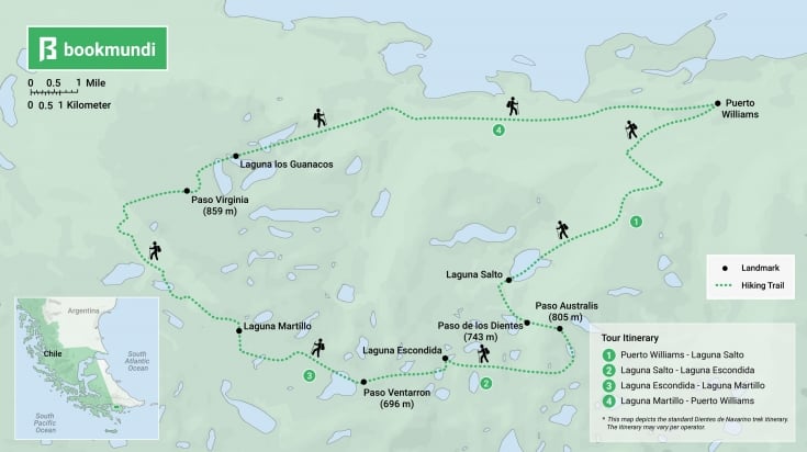
The Dientes de Navarino Circuit or Dientes Trek is approx. 42 km long and is hiked in 4 or 5 days. The Dientes de Navarino Circuit is classified as a wilderness trek and is only suitable for experienced hikers. The starting point is the idyllic fishing village of Puerto Williams.
ISLA NAVARINO TREKKING MAP
CAN I DO THE DIENTES DE NAVARINO TREK IN 4 DAYS?
Yes, you can hike the Dientes de Navarino Circuit in 4 days (suggested itinerary):
Day 1 - Transfer Puerto Williams – Cascada; Trekking to Laguna Salto; Camping Laguna Salto (hiking time: 4-5 hours, hiking distance: 9 km)
Day 2 - Trekking to Laguna Escondida; Camping Laguna Escondida (hiking time: 5 hours, hiking distance: 9,5 km)
Day 3 - Trekking to Laguna Martillo; Camping Laguna Martillo (hiking time: 5 hours, hiking distance: 8 km)
Day 4 - Trekking over the Virginia Pass to Bahia Virginia; Transfer to Puerto Williams (hiking time: 7-8 hours, hiking distance: 15 km)
WHY SHOULD I HIKE WITH A LOCAL TOUR COMPANY ?
An experienced and certified MOSER Active trekking guide always provides a high level of additional safety. With the satellite phone, he or she can call for help in the event of an injury, knows the pitfalls of the trails and, last but not least, can point out many things that you might otherwise not have noticed while hiking past. The Dientes de Navarino trekking guide will give you lots of useful insider information about the flora, country and people while you are hiking. If you hike with a hiking guide and porter, you also have the advantage of being able to hand over your tent, cooking utensils and food and thus lighten your rucksack by many kilos. But even if you are accompanied by a professional guide, it is important that hikers are physically fit and able to cope with the demands of a multi-day wilderness trek at the start of the trip.
If you book the "Dientes de Navarino Trek" with a local Isla Navarino tour operator like MOSER Active, an experienced, certified guide and the porters for tents, cooking equipment and food are always included in the tour price.
WHAT DO I HAVE TO CARRY MYSELF ON A GUIDED DIENTES DE NAVARINO TREK?
MOSER Active porters are available to transport tents, cooking utensils and food for breakfast and dinner. However, every hiker must be able to carry their own rucksack with sleeping bag, sleeping mat, personal belongings, change of clothes and washing utensils as well as packed lunches for on the way.


Do I have WIFI, cell phone or Internet reception on the Dientes Trek in an emergency?
No, you will not have cell phone or internet reception during the 4-day trek on Isla Navarino. It is therefore advisable to hike the Dientes de Navarino Circuit guided by a local trekking company.
How to get to PUERTO WILLIAMS - ISLA NAVARINO?
By plane to Santiago de Chile. In the high season, continue by domestic flight to Punta Arenas and then with the regional airline DAP to Puerto Williams.
When Is the Best Time to Visit Isla Navarino?
The optimal time to travel to Isla Navarino is during the southern summer, between mid-December and mid-March. Within that season, the very best weeks are from the end of January to the middle of February. As with other places in Chile, the weather is unpredictable and you may experience up to four different seasons in one day. Just remember to be prepared and flexible with your activity plans.
WHAT IS THE WEATHER LIKE ON ISLA NAVARINO?
In Tierra del Fuego, the weather can change several times a day or even in an hour. You can experience summer heat and snowstorms or wind gusts in a short time. You will notice that especially on the days you will cross mountain passes Australia, Ventarron and Virginia. Thunderstorms, however, are very rare.
BOOK YOUR NEXT ISLA NAVARINO ADVENTURE NOW !


DO I NEED GAITERS AND TREKKING POLES?
It is common to cross snow fields on the Isla de Navarino trek. Even in the summer, it can snow on the island. The remainder of the winter snow fields don't melt until the end of the summer. Not only do you need gaiters to cross the snow, but you’ll want them for muddy terrain, as well, as it’s possible to sink up to ankle-deep in the mud. Trekking poles are also a great help when crossing beaver dams, slippery gravel slopes and swampy terrain. If you don't bring your own, you can hire it from MOSER Active or from a gear rental shop in Puerto Williams.
CAN I DRINK FROM THE RIVERS AND STREAMS?
Yes. On each day of the trek, you can find fresh drinking water along the way. You will not need to carry huge amounts of water with you. The water is perfectly clean (almost) everywhere - your MOSER Active guide knows where to find the highest-quality drinking water.
WHY SHOULD I HIKE THE DIENTES DE NAVARINO TREK ONCE IN A LIFETIME?
The Dientes de Navarino Trek is the southernmost hiking trail in the world and one of the last true wilderness treks. Partly pathless, it takes you across the almost uninhabited Antarctic island through an untouched primeval landscape. A multi-day trekking tour on Tierra del Fuego that takes you along glistening mountain lakes, beaver dams and the rugged rocky peaks of the Dientes de Navarino mountains.
Are there alternative activities in case of bad weather?
If the weather does not allow you to cross the mountain passes and to camp out in the wilderness, there are other opportunities for outdoor adventure. Our guides know plenty of short and easier treks on Isla Navarino. Inclement weather is also a great time to visit Puerto Williams, the southernmost village of the world. Its harbor hosts an old steam boat that originally sailed on the Rhine River. The town also boasts a very interesting museum dedicated to the native indigenous population and their culture.
WHY IS ISLA NAVARINO ALSO CALLED “ISLAND OF THE BEAVERS”?
In the 1950s, beavers were released on the big Tierra del Fuego Island and made their way to Isla Navarino. As they don't have any natural enemies, their population could spread very fast, from approximately 10 to 120,000 s. Therefore, you have an excellent chance to see beavers while trekking the Dientes de Navarino Circuit. You will almost certainly see their burrows and dams, which are used by hikers as bridges to cross the rivers. You may also see minks in the wild. They have escaped from a mink farm in Argentina and have risen and increased so much in population that they are endangering the ecosystem of the island.
What Are the Top Activities on Navarino Island?
Outdoor adventures abound for those who travel to the end of the earth – to Ushuaia, across the Beagle channel and, finally, to Isla Navarino. Within this unfettered, most unpopulated wilderness, outdoor enthusiasts can hike, fly fish, camp, go horseback riding, flight-see over Cape Horn and watch for the black-browed albatross.
TRAVEL STORY: The Dientes de Navarino Trek is the world's southernmost trekking tour

The Dientes de Navarino Trek takes four to five days across the Antarctic island of Isla Navarino and has a few adventures in store: the route is partly pathless through swampy terrain. Passes at 800 meters await with snowfields. In untouched valleys with southern beech forests, you are immersed in a true primeval landscape.
.
Pure solitude is guaranteed on the virtually uninhabited island of Isla Navarino. On the four- to five-day trek around the impressive Dientes de Navarino massif, the only thing you will be disturbed by is a few beavers, which have spread massively across the island. Their dams serve as bridges for hikers. There is virtually no man-made infrastructure. "The Dientes de Navarino Trek is still completely unknown, but is one of the most beautiful wilderness treks in southern Chile," explains Vera Stölzner. On a trekking trip to Patagonia, the German mountain guide and former tax consultant not only fell in love with the region, but also with her trekking guide Christian Moser, an Austrian and pioneer of trekking tourism in Patagonia and Tierra del Fuego. For around 20 years, Christian has been offering tours in South America with his trekking company "Moser Active", which he has often explored or developed himself - together with Vera for several years now.
Journey to the end of the world - what sounds like the title of a movie or novel is meant literally: at the tiny airport of Punta Arenas, located in Patagonia in southern Chile, I board a small plane with Vera and Christian to fly to the even tinier airport of Puerto Williams. With us is Gerard Josseau, a young "Magallanico", as the inhabitants of the region around the Strait of Magellan call themselves. He is on our tour as a porter and budding mountain guide. "I've never been to Isla Navarino before, but I've heard from my colleagues that there's nothing as beautiful and wild as it," says Gerard happily.
And the flight itself is an adventure: we fly over the countless fjords and islets of the frayed southern tip of South America, cross the infamous Strait of Magellan and head straight for Antarctica. Shortly before Cape Horn, the plane descends and appears to crash into the Beagle Channel behind the large Tierra del Fuego island - but then lands safely on Isla Navarino and in Puerto Williams, the southernmost settlement in the world. "The town was founded in 1953 as a naval base called Puerto Luisa, but was then renamed Puerto Williams in 1956," explains Christian. Captain Williams played a major role in the settlement history of the Magellan region. In the harbor, we are greeted by a genuine Rhine steamer, among other historically significant ships, which amazingly has made it halfway around the world.
.
FAREWELL TO THE BEAGLE CHANNEL
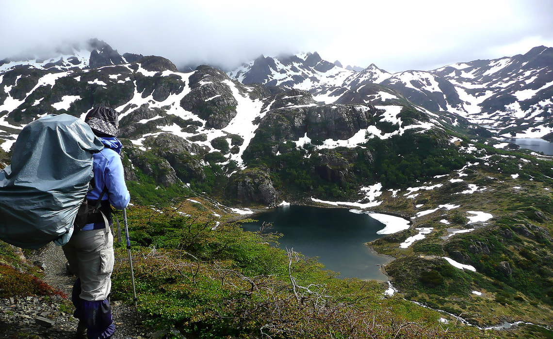
Every trekking tour on the island of Navarino starts with registration with the local police authority. This ensures that none of the few trekking tourists get lost in the wilderness. "Part of the island used to be a restricted military area," explains Vera. As a result, nature is completely untouched - and should remain so. "We try not to leave any traces behind on our tours and take everything back with us, from toilet paper to banana peels," Vera emphasizes. On the first section - a steep climb with fascinating views of the Beagle Channel and the large Tierra del Fuego island - we follow a signposted path. The path to Cerro Bandera, our first summit destination, is a popular excursion with the locals. Two hikers are standing at a viewpoint with a bench. This is to be the last human encounter until our return to Puerto Williams. Only once more will we see two tents from a distance.
From the flagged summit of Cerro Bandera, we overlook large parts of the waterway between the Pacific and the Atlantic, which was discovered by the sailors of the British explorer ship Beagle in 1831. On board was the young Charles Darwin, whose future research was decisively influenced by the Tierra del Fuego voyage. We soak up the last glimpse of the strait before immersing ourselves completely in the mountains for a few days.
From Cerro Bandera onwards, there is no longer a clear route or a well-developed path. "Under no circumstances should you forget your gaiters," Vera had emphasized in the run-up to the trip. Now it becomes clear why: we sink ankle to knee-deep into the mud as we cross the high plateau. Soon afterwards, we cross the first snowfields. And then we see them for the first time: the "dientes", the rocky peaks around which our trek will take us. With their dark rock of volcanic origin, they stand out ruggedly against the green valley. The peaks, up to 1,195 meters high, are covered in snow.
"It can snow on the island even in summer," reports Vera. Some old snowfields don't melt until the end of the season. The weather on Isla Navarino can change several times a day and even several times an hour. "We have often experienced a snowstorm and summer heat within a very short space of time," says Vera. The only constant is the wind, which tugs at hikers, especially when crossing passes. Heavy thunderstorms are rather rare.
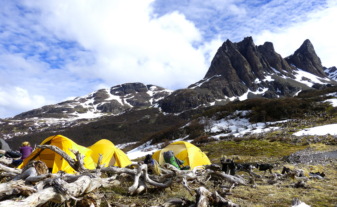
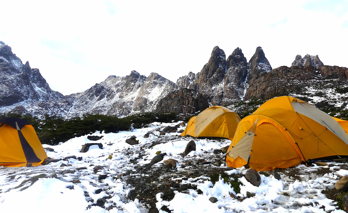
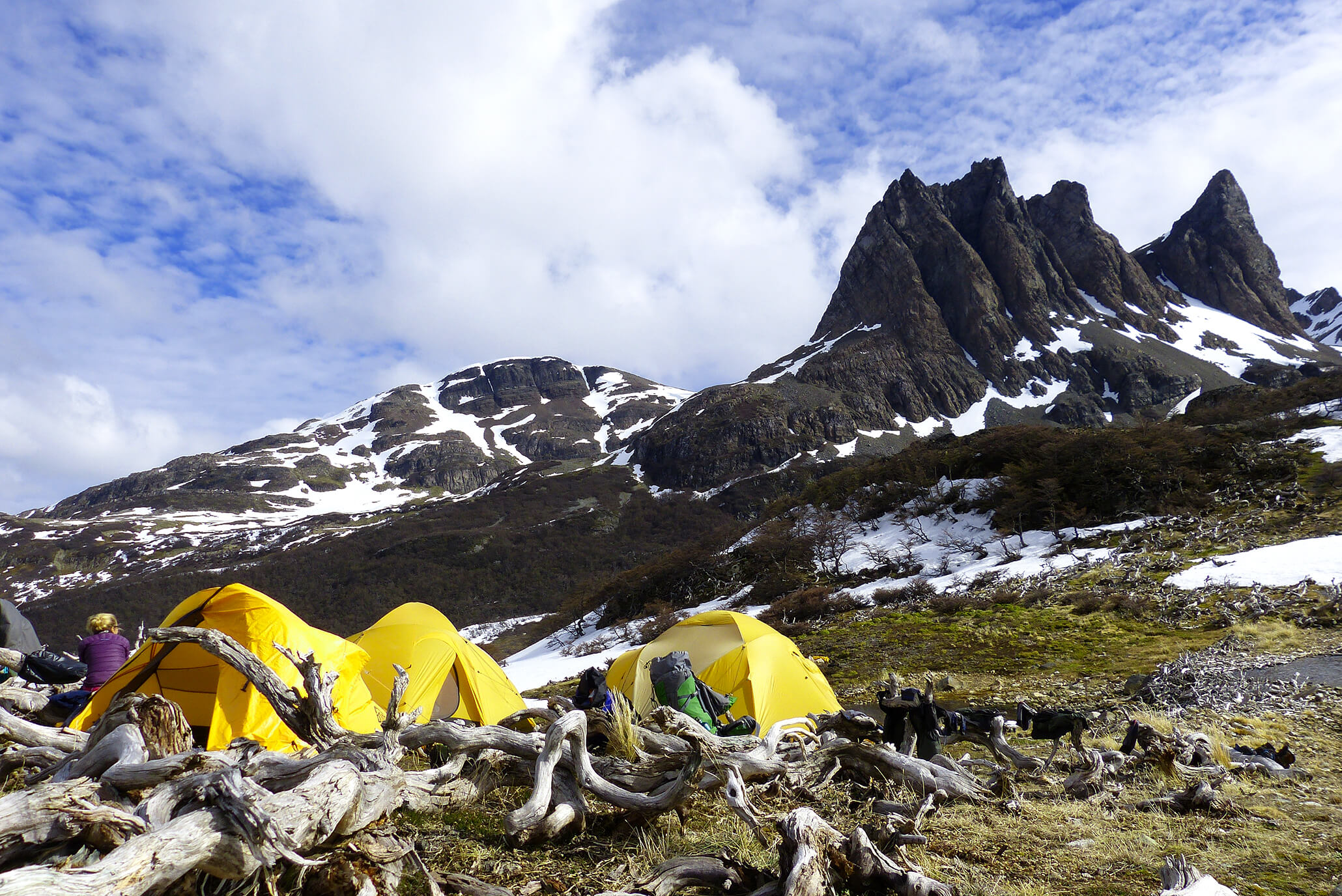
The wind also makes pitching the tents a challenge. We set up our first camp at the Laguna del Salto. Vera and Gerard conjure up fresh fruit and vegetables from their rucksacks - some of which they have brought with them by plane from Punta Arenas. "You learn to both plan and improvise here," laughs Christian. Supplies are sometimes difficult on the island. Important goods, craftsmen and even teachers for the children are flown in every day. Food is brought in once a week on a 36-hour boat trip from Punta Arenas.
.
BEAVER ISLAND NAVARINO
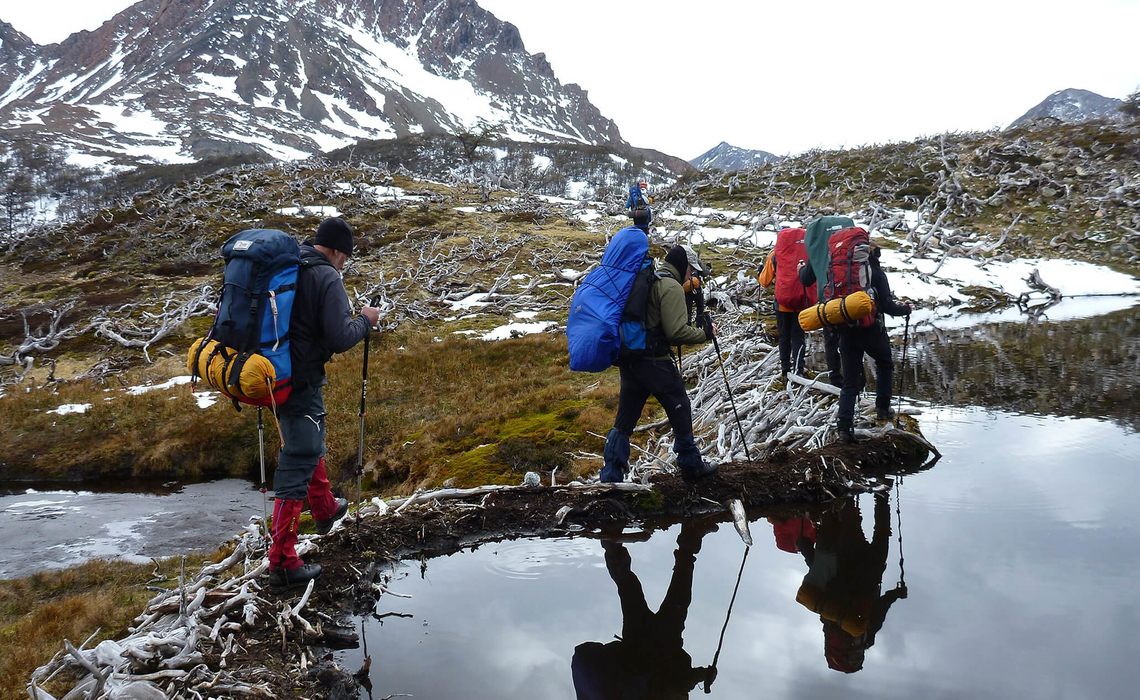
However, there is plenty of water on the island, which we fill up for cooking and drinking from the numerous streams that flow down to the lagoon - a mountain lake in a trough valley created by glaciers. On Isla Navarino, you regularly pass watercourses and lakes on all stages where you can fill up your water bottle. "You just have to make sure that you don't tap directly below a beaver lodge", laughs Vera, "otherwise it can get disgusting". We encounter beaver lodges at every turn. They help us to cross the numerous larger rivers and even entire lakes. In many places, the southern beech forest is nothing more than a collection of bizarre sculptures made of dead trunks, such is the damage the beavers do to the trees.
In the 1940s, the rodents were released on the large island of Tierra del Fuego, from where they also reached Isla Navarino. Due to the lack of predators, the animals were able to multiply from around 10 to 120,000 specimens. Mink, which escaped Argentinian mink farms on Tierra del Fuego Island in 2001 and swam across the Beagle Channel, have also reproduced so abundantly that they are now damaging the island's sensitive ecosystem. "The birds are all ground breeders, as there were no carnivorous mammals on the island before," Vera reports as we struggle up to Paso Australia, one of the highest points of the Dientes de Navarino trek, on the second day.
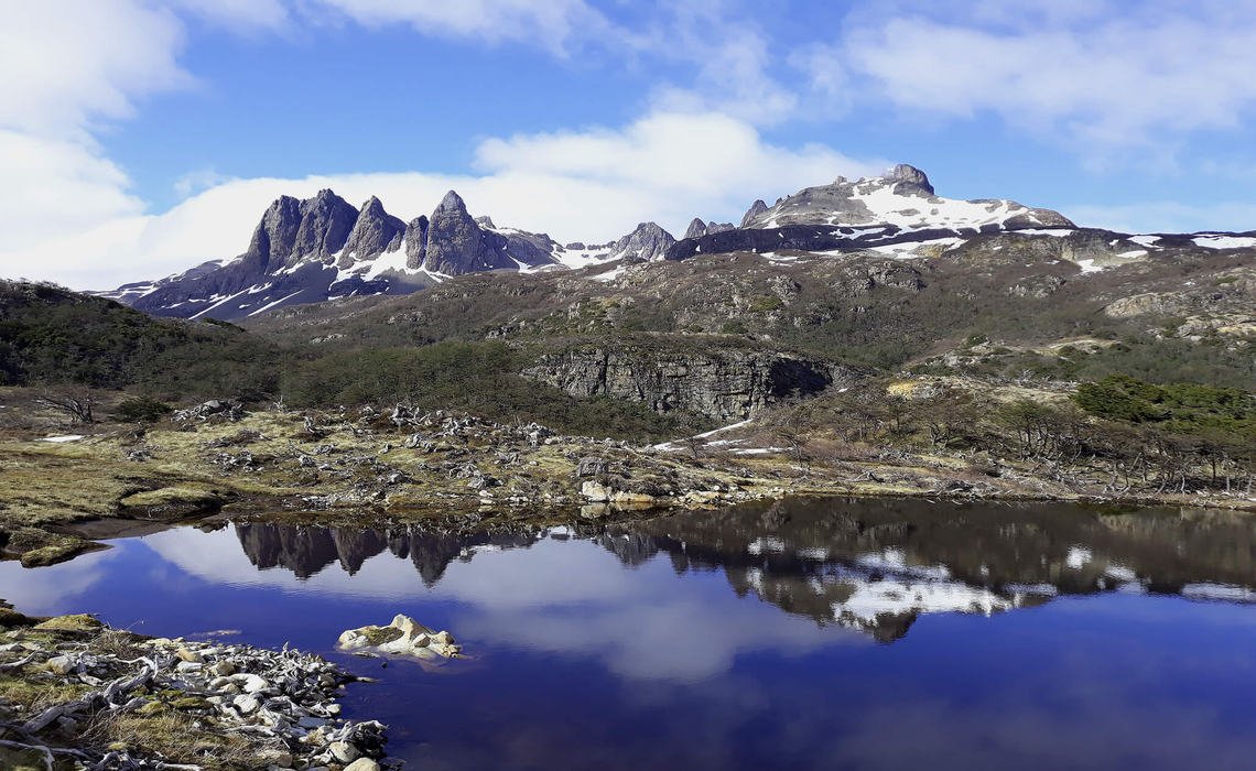
Even though the island's passes are barely higher than 800 meters above sea level, we have the feeling of being in the high mountains. "The tree line on Isla Navarino is around 500 meters above sea level," explains Vera. On the three passes of the second stage, the Paso Primero, the Paso Australia and the Paso de las Dientes, we cross rough gravel and brace ourselves with all our weight against the wind. A landscape spreads out beneath our feet that could be straight out of a (computer-generated) documentary about dinosaurs. Lagoon after lagoon are lined up, glistening in various shades of blue, gray and green.
.
MAGICAL LANDSCAPE
It is a truly magical landscape that amazes us with its remoteness and untouched beauty at every step. Even Christian, who explored the tour around the Dientes de Navarino back in 2003 and had already walked it with clients a few years later, stops, fascinated, when the islands of Cape Horn can be seen on the horizon in the pastel-colored haze. "We're unusually lucky with the weather," he notes. Only on the second evening did the rain force us to huddle together under a makeshift tarpaulin at Laguna Escondida for a few hours.
Christian has scouted out some shorter alternative routes of two to three days in case of bad weather. "The last day will be the most strenuous," he reports. "We have about 7 to 8 hours of pure walking time. We also have to cross the Paso Virginia, the last pass before the descent to the Beagle Channel, where snowstorms often occur. The last stage is often split up and we camp again at the Laguna Guanako, where - as the name suggests - there are said to be guanacos, the llama-like heraldic animals of South America. The last section is a real challenge: the route continues downhill through a dense forest with lots of undergrowth. Like an obstacle course, we duck under the fallen coigüe, lenga and Ñirre trees, climb over them or slide in the mud.
Then we're back in civilization. The small town with its colorful houses, the jingling sail masts in the harbor, the horses and dogs strolling freely through the alleys seems almost loud and shrill after the peace and quiet of the last few days. A special highlight awaits us at the end: just outside the town, the houses of the indigenous population, the Yámana, are grouped together in a small hamlet. We want to buy a pair of knitted socks as a souvenir from an old Yámana lady and are unexpectedly invited into the parlor, where we are told about the old days when there was no Puerto Williams.
Over a lavish dinner, Christian later explains what his work is all about: it's not just about physical activity, "but about taking something with you for later life, decoupling from everyday life, immersing yourself in other cultures and being thrown back to the basics". That is the essence of the Dientes de Navarino Trek.
Travel Story from Annika Müller